-
 Anglický jazyk
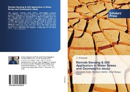
Remote Sensing & GIS Application in Water Stress and Geomorphic study
Autor: C. Prakasam
The present research work entitled "Geomorphic resource characterisation using Remote Sensing and Geographical Information System for evaluation of land use land cover in water stressed area" has been analysed and interpreted from different satellite data... Viac o knihe
Na objednávku, dodanie 2-4 týždne
83.25 €
bežná cena: 92.50 €
O knihe
The present research work entitled "Geomorphic resource characterisation using Remote Sensing and Geographical Information System for evaluation of land use land cover in water stressed area" has been analysed and interpreted from different satellite data and topographical maps. The objectives of the study was to estimate the available surface water resources using multi-temporal satellite data and SOI topographical maps; to find the importance of surface water resources for determining the landuse landcover of selected area. Based on geomorphic, LULC resources, the surface water resources and water harvesting potential zones were identified and then classified. Finally, author formulated new seasonal landuse plan for the region based on above resourses.
- Vydavateľstvo: Scholars' Press
- Rok vydania: 2017
- Formát: Paperback
- Rozmer: 220 x 150 mm
- Jazyk: Anglický jazyk
- ISBN: 9786202301503


 Nemecký jazyk
 Francúzsky jazyk